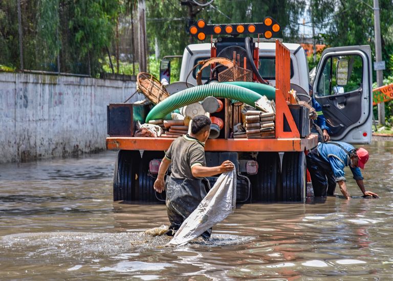
Texas communities already struggling with submerged roads, swollen waterways and repeated high-water rescues are preparing for another potentially destructive round of storms. The most serious threat now extends across South Texas and the western Hill Country, where saturated ground could turn additional rainfall into fast-moving flash floods with little warning.
We are watching the U.S. 90 corridor west of San Antonio emerge as the center of the danger. Uvalde, Hondo, Bandera, Del Rio and surrounding rural communities face an unusually severe rainfall outlook as tropical moisture feeds slow-moving thunderstorms over areas that have already received more than 10 inches of rain.
The National Weather Service has placed parts of the Rio Grande Plains, southern Edwards Plateau and western Hill Country under a Level 4 of 4 risk for excessive rainfall. That highest-level designation signals that considerable flooding is expected and that locally catastrophic impacts are possible.
Uvalde Flooding Triggers Rescues, Closures and Shelter Operations

The emergency was already unfolding before the most dangerous period of the forecast arrived. Heavy rain inundated Uvalde County on Tuesday, forcing motorists from flooded vehicles and prompting emergency teams to navigate streets and roadways by boat.
Local officials reported at least two dozen water rescues in Uvalde. An event center was opened for residents displaced by the flooding, while authorities in nearby Sabinal prepared shelter arrangements in case conditions deteriorated further. Initial reports from Tuesday indicated no confirmed deaths or injuries.
Texas game wardens also joined the rescue effort. Five people were rescued by a specialized Texas Game Warden Search and Rescue Team, while a local game warden rescued four others. Those numbers may overlap with rescues reported by local agencies, so they should not automatically be added to the Uvalde total.
Elsewhere, Medina County reported at least four high-water rescues before Tuesday morning. Drone footage documented widespread flooding in D’Hanis, while officials said roads throughout the county had become impassable. Despite the dangerous conditions, Medina County authorities initially reported no deaths, injuries or flooded buildings.
U.S. 90 Becomes a Critical Flooding Corridor
One of the clearest signs of the storm’s impact appeared along U.S. 90, an essential transportation route connecting communities west of San Antonio. Floodwater covered the highway between Sabinal and Knippa, forcing authorities to close the roadway for hours.
Nearly seven inches of rain had been measured near Sabinal before 8 a.m. Tuesday, and some surrounding locations received considerably more. Other sections of U.S. 90 in Uvalde, Medina and Bandera counties were also affected by high water, debris and emergency closures.
Road flooding in this region can develop rapidly because highways frequently cross creeks, drainage channels and low-lying terrain. Water moving across pavement may conceal washed-out sections, sharp debris or strong currents capable of displacing a vehicle.
We should therefore treat every barricade as a warning of an active hazard rather than an inconvenience. Drivers who encounter water covering a road should turn around immediately and seek a verified alternative route. The National Weather Service emphasizes that a large share of flood deaths occur in vehicles.
Additional Rainfall Could Reach 10 to 20 Inches
The greatest concern is no longer the rain that has already fallen. It is possible that intense thunderstorms will repeatedly pass over the same saturated communities.
Forecast guidance indicates that most locations in the flood watch area could receive another 2 to 6 inches of rain. Isolated pockets across the Rio Grande Plains, southern Edwards Plateau and western Hill Country may receive an additional 10 to 20 inches through Thursday.
Rainfall rates could exceed four inches per hour under the strongest storms. At that intensity, dangerous flash flooding may begin within roughly 30 minutes, particularly where soil can no longer absorb additional water.
Uvalde, Hondo, Bandera and Del Rio sit within or near the highest-risk zone. San Antonio and portions of the Interstate 35 corridor also face a significant threat, with widespread totals of two to six inches and isolated amounts approaching 10 inches possible in parts of the metropolitan area.
Why Saturated Ground Makes the Next Storm More Dangerous
The current Texas flooding threat is a compounding event. Each round of rain leaves the soil less capable of absorbing the next downpour, causing a larger percentage of new rainfall to flow directly into streets, creeks, rivers and drainage systems.
Thunderstorms may also stall or repeatedly move across the same locations. This process, often described as training, can produce extreme rainfall totals across a relatively narrow corridor even when nearby communities receive much less rain.
Forecasters warned that soils across the Rio Grande region, Edwards Plateau, western Hill Country and U.S. 90 corridor were already saturated. Under those conditions, additional heavy rain can create rapid runoff, sudden creek rises and flooding far from the center of the strongest storm.
Texas Disaster Declaration Covers 59 Counties
Governor Greg Abbott issued a disaster declaration for 59 counties as the severe-weather threat expanded across Southwest, Central and Southeast Texas. The declaration allows state officials to deploy personnel, rescue equipment and logistical support more rapidly when local resources become strained.
The Texas State Emergency Operations Center remains active around the clock at Level II, described as an escalated response posture. Ten state entities were directed to ensure that resources were ready for deployment.
Those agencies include the Texas Department of Transportation, the Department of Public Safety, the Texas Parks and Wildlife Department, the Texas National Guard, and emergency medical teams. Health, forestry, engineering, agricultural support and cybersecurity agencies were also placed on readiness status.
This coordinated response is especially important in rural counties, where volunteer departments and small emergency management offices may handle multiple rescues, road closures, and shelter operations simultaneously.
Kerr County Faces Renewed Anxiety After the 2025 Disaster
The flood watch also includes Kerr County, where communities remain deeply aware of how quickly Hill Country waterways can become deadly. Catastrophic flooding along the Guadalupe River in 2025 killed more than 100 people, leaving families, camps and riverside communities confronting a prolonged recovery.
The current storm is a separate weather event, and no comparable casualty toll has been reported. However, the earlier disaster has heightened attention to warning systems, riverside camps, evacuation planning and nighttime rainfall.
Flood danger in the Hill Country is intensified by steep terrain, shallow soils and narrow river valleys. Heavy rain falling upstream can send water rushing toward downstream communities even when the worst storm is not directly overhead.
Residents near the Guadalupe, Nueces, Frio, Sabinal and other waterways should therefore monitor conditions beyond their immediate neighborhood. A calm period at one location does not guarantee that a dangerous surge is not developing upstream.
Flood Watches, Warnings and Emergencies Mean Different Things
A flood watch means conditions are favorable for flooding, but it does not guarantee that every community inside the watch area will flood. Residents should use that time to charge phones, secure outdoor property, review evacuation routes and prepare to act.
A flash flood warning means dangerous flooding is occurring or expected soon. People in the warning area should move away from low-lying crossings, creeks, drainage channels, and flood-prone roads without waiting to see water rise nearby.
A flash flood emergency represents an exceptionally difficult and life-threatening situation. It may indicate destructive flooding, rapidly rising water, stranded residents or an immediate threat to homes and major transportation routes.
Because warning boundaries can change quickly, residents should keep Wireless Emergency Alerts enabled, follow local emergency management messages, and maintain multiple ways to receive weather information.
What Residents Should Do Before the Next Downpour
We should prepare for the possibility that electricity, cellular service and road access may be disrupted. Phones and backup batteries should remain charged, medications should be accessible, and vehicles should be moved away from low-lying parking areas when it is safe to do so.
Families should identify the safest location available and determine how they would evacuate if officials issue an evacuation order. Essential documents, drinking water, flashlights, pet supplies and basic first-aid materials should be gathered before storms intensify.
People staying at campsites, recreational properties or homes near rivers require additional caution. The National Weather Service warns that heavy rain can cause streams and rivers to rise quickly, making low-lying campsites especially dangerous.
Motorists should verify road conditions before leaving and avoid relying entirely on navigation applications. A mapping service may continue directing traffic toward a flooded crossing or recently closed highway because emergency road information has not yet updated.
The Texas Flood Threat Continues Through Thursday
Forecasters expect several rounds of showers and thunderstorms through Thursday evening. The most serious danger is concentrated west of San Antonio, but flooding remains possible across a much broader area that includes the Hill Country, Rio Grande Plains and Interstate 35 corridor.
Storm coverage may temporarily decrease between rounds, but any lull should not be interpreted as the end of the emergency. Additional thunderstorms can redevelop quickly, and runoff may continue raising creeks and rivers long after rain stops at a particular location.
Conditions are expected to become less favorable for widespread heavy rain later in the week. Until then, the combination of tropical moisture, saturated soil and repeated thunderstorms leaves South Texas facing a dangerous and unpredictable flood emergency.